ORMA logoORMA
All trails › Dolomites, Italy › Val di Fassa

I segreti di una volta

the old farmland walk above Pozza

Best time: April to October Caution terrain Verified by ORMA
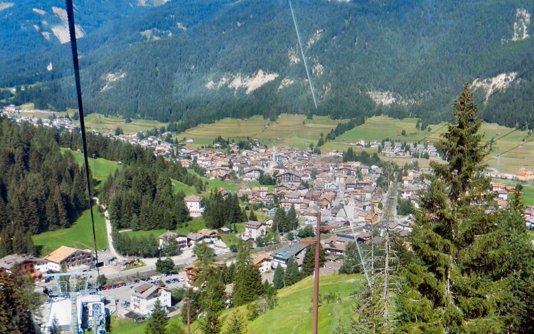
Pozza di Fassa among green meadows and woods seen from a cable car, the mountains of the valley behind
C
Pozza and its meadows by Bbruno CC BY-SA 3.0 Cropped for display.

A gentle loop from Vigo along the meadows above Pozza to Pera, on the old Ladin farmland, facing the Costabella and the Vallaccia. The APT lists 7.9 km and 176 m of ascent.

Distance
7.9 km
Elevation gain
176 m
Highest point
1453 m
Duration
2 h 15 min
Terrain
Meadow and forest-edge paths, farm tracks and village lanes
Trail rating
Caution terrain
Area
Vigo – Pozza – Pera, San Giovanni di Fassa / Sèn Jan · Dolomites, Italy
Open the full trail guide →
1453 m 1296 m 7.9 km
Elevation profile: lowest 1296 m, highest 1453 m.

When to go

  1. January: Outside the season
  2. February: Outside the season
  3. March: Outside the season
  4. April: Recommended
  5. May: Recommended
  6. June: Recommended
  7. July: Recommended
  8. August: Recommended
  9. September: Recommended
  10. October: Recommended
  11. November: Outside the season
  12. December: Outside the season

Recommended from April to October.

Source: Outdooractive, read on 6 November 2026.

For your dog

March to April: pine processionary caterpillars come down from the pines below about 1400 m, and they are a danger to dogs. Keep your dog away from pines and from the caterpillars.

Source: Province of Trento, forestry service, read on 9 November 2026.

June to September (an estimate): cows may be out on the pastures. Keep your dog close and give the herds a wide berth.

Source: South Tyrol tourist board, read on 9 November 2026.

December to February (an estimate): the roads and lanes on this walk may be salted when they ice over. Salt hurts dogs’ paws: check them after the walk and rinse them with warm water.

Source: Province of Bolzano weather service, Bozen station temperatures, read on 10 November 2026. German Federal Chamber of Veterinarians, read on 10 November 2026.

Where to start

Vigo di Fassa (Strada de Piz), the APT’s start

How to follow this route

This walk has no trail number of its own: follow these landmarks

Start in the centre of Vigo, the tourist board’s start.

  1. From the centre of Vigo, walk up Strada de Piz and turn right by a covered fountain. A little further on, cross the Ruf de Pantl stream and carry on along an easy gravel forest road, mostly shaded, with benches and tables in the open spots.
  2. The road runs above Pozza, then loses height across the meadows near the first houses of Pera (Strada de la Taboca).
  3. Once at the main road, walk towards the centre of Pozza along the pavement, or on the walk across the Ciancoal meadows. From the Media roundabout, follow Strada di Bagnes, past the QC Terme spa.
  4. Past the water treatment works, cross the footbridge over the Avisio and walk up Strada de Pala Verda.
  5. Cross the main road and follow the lane along the wall of the parish church of San Giovanni, then Strada Antersief, Strada Roma and Strada Rezia back to the centre.

Directions: Val di Fassa tourist board, checked 29 October 2026.

Water on trail

Rifugi & refreshment

Good to know

Start in Strada de Piz in Vigo: 7.9 km, about 180 m of climbing, two hours and a quarter. Keep your dog on a short lead (1.5 m at most), carry a muzzle and keep out of the mown meadows. Fountains in Vigo, Pozza and Pera.

Verified by ORMA on 26 Oct 2026. Check current conditions before setting out.

Is this trail right for your dog?

The trail rating above describes the mountain, and it's the same for every dog. How it suits yours depends on their build, age and health. See this route's match — scored for a medium dog until you add your own, free and in a minute.

Before you go: the dog safety guide · water for dogs on trail · dogs on cable cars · meeting a guardian dog

Nearby trails