ORMA logoORMA
All trails › Dolomites, Italy › Primiero – Pale

Anello di Valpiana

the forest loop to Malga Valpiana

Best time: March to October Caution terrain Verified by ORMA
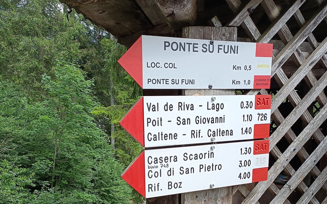
Red and white trail signs on a wooden post at the Rifugio Fonteghi, pointing to Ponte su Funi, Val de Riva, Poit – San Giovanni and Caltene, green forest behind
C
The signpost at the Rifugio Fonteghi by 501ghost CC0 Cropped for display.

A shaded forest loop in the Val Noana from the Rifugio Fonteghi to Malga Valpiana and the meadows of Valpiana, among great firs and beeches. The APT lists 5.2 km and 184 m of ascent.

Distance
5.2 km
Elevation gain
184 m
Highest point
1236 m
Duration
1 h 30 min
Terrain
Gravel forest roads and a forest path
Trail rating
Caution terrain
Area
Rifugio Fonteghi – Valpiana, Val Noana, Mezzano · Dolomites, Italy
Open the full trail guide →
1236 m 1100 m 5.2 km
Elevation profile: lowest 1100 m, highest 1236 m.

When to go

  1. January: Outside the season
  2. February: Outside the season
  3. March: Recommended
  4. April: Recommended
  5. May: Recommended
  6. June: Recommended
  7. July: Recommended
  8. August: Recommended
  9. September: Recommended
  10. October: Recommended
  11. November: Outside the season
  12. December: Outside the season

Recommended from March to October.

Source: Outdooractive, read on 6 November 2026.

For your dog

March to April: pine processionary caterpillars come down from the pines below about 1400 m, and they are a danger to dogs. Keep your dog away from pines and from the caterpillars.

Source: Province of Trento, forestry service, read on 9 November 2026.

March to June: ticks in the woods below about 1200 m, most of all from late May to mid-June. Check your dog after the walk.

Source: Province of Trento and Fondazione Edmund Mach, read on 9 November 2026.

June to September (an estimate): cows may be out on the pastures. Keep your dog close and give the herds a wide berth.

Source: South Tyrol tourist board, read on 9 November 2026.

Where to start

Rifugio Fonteghi, the APT’s start

How to follow this route

This walk has no trail number of its own: follow these landmarks

Start at the Rifugio Fonteghi, the tourist board’s start.

  1. From the Rifugio Fonteghi, take the road that leaves on the right. After about ten minutes, turn right onto the forest road called “Valpiana Aie”, which climbs in hairpins to Malga Valpiana.
  2. At the malga, take the gravel road down to the right and carry on to the Casina Forestale di Valpiana.
  3. There, turn right again onto the gravel road past the Casina. It runs level along the side of Monte Piadochìn, with the meadows of Valpiana di Sotto below.
  4. The road winds through the meadows and huts of Valpiana di Sopra. Beyond them it becomes a path that goes down back to the Rifugio Fonteghi.

Directions: San Martino di Castrozza, Primiero and Vanoi tourist board, checked 29 October 2026.

Water on trail

Rifugi & refreshment

Good to know

Start at the Rifugio Fonteghi in the Val Noana: 5.2 km, about 180 m of climbing, an hour and a half. Keep your dog on a lead near the malga and any grazing cattle. Water at the rifugio and near the end.

Verified by ORMA on 26 Oct 2026. Check current conditions before setting out.

Is this trail right for your dog?

The trail rating above describes the mountain, and it's the same for every dog. How it suits yours depends on their build, age and health. See this route's match — scored for a medium dog until you add your own, free and in a minute.

Before you go: the dog safety guide · water for dogs on trail · dogs on cable cars · meeting a guardian dog

Nearby trails